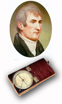
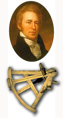
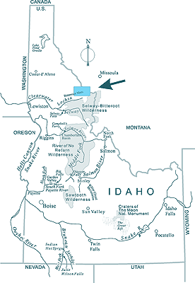
The crossing of the Bitterroot Mountains: of all the parts of their amazing 4,000-mile journey across the continent, from the mouth of the Missouri to the Pacific, this was the one that challenged Lewis and Clark like no other. Lewis called it "the most formidable part . . . [over] tremendous mountains which for 60 miles are covered with eternal snow." A few years ago, my wife Kathy and I decided it might be fun to do a ski traverse, following the same route that Lewis and Clark's route took across the Bitterroots. This is the story of the trip.
We awoke to a world of silence and mist. It completely surrounded us. All during the time we were finishing breakfast and taking down camp, the mist was present, first rising up from the depths of the canyon below, then curling in among the undulations of the snow covered terrain and obscuring everything in the distance. It brought with it an eerie quietness. Even our voices seemed to be absorbed into it, words disappearing as quickly as they were uttered.
We hefted packs and shoved off on our skis, following the narrow trail through the stillness and a stand of mountain hemlock. The tall dark trees with branches laden with strands of Spanish moss jutted upwards . . .and stealing among branches was the mist.
There was something foreboding about it all. The silence, the mist, the dark trees, the snow. It gave me a shiver. It was just the two us. We were halfway across now. Would we make it? I wondered. I side stepped around a rocky outcropping and my thoughts wondered again as I watched the back and forth swing of my skis, sliding across a snow surface speckled by Spanish moss and hemlock needles. If I was feeling this way, what must it have been like 200 years ago? Maybe, just maybe, the way I felt was a tiny pinch of what it must been like for Lewis and Clark.
The two explorers and their band of some thirty men passed this way. Among them, and hunched over her horse as snow fell, was Sacagawea with her child, 6-month old, Jean Baptiste. Among them also was Old Toby, their Shoshoni guide, alert for signs of the trail. Lewis and Clark had put a lot of trust in Toby. Many of Toby's fellow Shoshonis said that it wasn't possible for the party to get across the mountains. And Lewis must have wondered at that point if Toby really could get them through. He had already lost the trail a day earlier--and by the time the expedition had gotten back on track, food supplies were running desperately low.
 Of all the parts of their amazing 4,000-mile journey across the continent, from the mouth of the Missouri to the Pacific, this was the one that challenged them like no other. Lewis called it "the most formidable part . . . [over] tremendous mountains which for 60 miles are covered with eternal snow." Sergeant Patrick Gass described the terrain even more succinctly as "the most terrible mountains I ever beheld."
After hundreds of miles across the open plains, the Corps of Discovery found themselves suddenly hemmed in, imprisoned by what is now called the Bitterroot Range of present day Idaho. Clark called this land of endless mountains, downed trees, and of snow and cold, a place "impossible to escape." Their hunger didn't help matters. There was no game in the mountains, and even Drouillard, a hunter and woodsman of consummate skill was coming back empty handed.
The mood among the party sunk to rock bottom. "The want of provisions," Clark wrote in a passive tone, "together with the difficulty of passing the mountains, dampened the spirits of the party."
It wasn't only the terrain. It was also the snow and the cold. Even though it was only mid September, winter was already gaining a toe hold. The ancient Indian trail that they were following was on a high ridge, exposed to the weather and wind. The wind can be violent as it rakes the high ridges of the Bitterroots. Then and now. Even in the relative protection of a stand of hemlock trees I could see what the wind could do as I looked at the snow surface littered with tree limbs, Spanish moss, and needles.
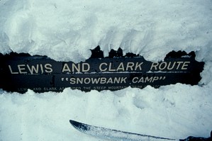
It was September 16th when the Corps of Discovery passed where we had made our camp. It was a wretched day for the party, the most wretched of their journey. It snowed all day, accumulating six to eight inches deep, wetting their clothing, chilling them to the bone. "I have been wet and as cold in every part of as I ever was in my life;" Clark wrote in his journal, "indeed, I was at one time fearful my feet would freeze in the thin moccasins I wore."
But they were only beginning their march through those terrible mountains which, from every vantage point, stretched without break into the distant west. All they wanted to do is get through those mountains and back down to low country, away from the snow and cold and gnawing hunger. But, on that cold and miserable day, it must have seemed an impossibility as they climbed higher and the snow piled deeper.
The Lewis & Clark trail where it follows the spine of the Bitterroot Mountains, about 35 air miles to the southwest of Missoula, Montana is one of the most fascinating segments of their historic journey--and it's the one portion that's still very much the way it was in 1805. When one looks at their route in its entirety, very little of it was in the mountains. Most of it was in the great prairies of the lower and middle Missouri watershed, or the valleys between mountain ranges in the upper Missouri, or the plateau country of the Columbia River. But here they were in the midst of the Rocky Mountains, an up and down terrain far more intimidating than anything they had ever experienced.
It was--and is--a land of incredible diversity. Among the thickly timbered and brushy lower elevations are magnificent stands of cedar, and, in the shaded forest floor beneath, a dazzling array of ferns and mosses. Even in the high elevations where the forest thins out, Lewis reported observing "eight different kinds of pines." (They were, most likely, according to the late forester, Ralph Space: Hemlock, White Pine, White Bark Pine, Lodgepole, Doug Fir, Grand Fir, Sub Alpine Fir and Englemann Spruce.)
Among this diversity, there is one thing ever present: snow. Snow begins in September, and once it takes hold, layer upon layer of it builds--twelve foot snow packs are not unusual for the high elevations--and winter lasts and lasts. The roads in the high Bitterroots often do not open until some time in July. Then fall comes, they quickly close, and winter begins again.
Does that sound a little like heaven for a cross-country skier? Indeed! But there's more. Add a little scenery: the Lewis & Clark route follows a high and airy route with wonderful views of "tremendous mountains." Finally, top that off with a route that's eminently doable on skis. The route follows something called the Lolo Motorway, an old and very narrow road completed in 1934. Fortunately the Forest Service has left it as is. In summer, it's a great mountain bike trip. In the winter with snow, it narrows down to something resembling a . . . well, a cross-country ski trail. I can't think of a more perfect route for a multi-day winter trip. Since the Lewis & Clark bicentennial was just getting underway, I decided, what the heck, why not go for it and began laying plans for the trip.
 The trip was planned for spring break at the university where I work. Since the break fell in mid March, we'd be on the trail just before the spring equinox. Officially, it's the tail end of winter, but in the high Bitterroots, mid March is still very much mid winter, particularly when you consider that the Lolo Motorway is not usually passable until early July.
Then it came to assembling a party. I thought I had all the ingredients of a great trip-- bountiful snow, beautiful country, and fascinating history--but when I tried to interest friends and university students in the trip, I couldn't find any takers. Perhaps it was too late in the season and their thoughts had already turned to summer, but, fortunately, my wife Kathy came to the rescue. Actually, she had been excited about the trip from the very beginning. Thus, in the end, our party consisted of just the two of us.
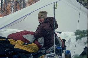
Not having a larger group to help spread out the load, we began paring the weight down, chiefly deciding against a tent but taking instead a tarp for shelter. It's not nearly as nice as a tent--and you have to be much more particular in finding protective areas in the trees for camping--but, having used a tarp for some previous winter camping trips, I knew it would get us by. (Admittedly, at the start of the trip, I was a bit overconfident of my sheltering abilities. During a storm on the last night of the trip, the tarp did have its drawbacks, as you'll see.)
* * *
It was a beautiful, sunny morning when Mike Lewis pulled into the small pull-off at the mouth of Papoose Creek. In the short drive, Mike had been filling us in on what the trail would be like and what landmarks to look for. "Sure wish I was joining you," he said as we unloaded the gear. With plaid shirt rolled to the sleeves, open friendly face--and a pair of cross-country skis in the back of his vehicle--he was the perfect person to tell us about the country.
For years, Mike had worked in the Bitterroots. Originally from Vinton, Iowa, Mike had first come to these mountains by working summers on a trail crew for the Forest Service. Seasonal work turned into full time work and the Bitterroots became his new home. And, then, as we all do as we advance up the professional ladder, he moved on to work for other Forests, but, all the time, he was homesick for the Bitterroots. Finally, he could stand it no longer, and selling all his possessions, he bought a motor home and came back home. Now he lives in his motor home and works at Lochsa Lodge, a small, rustic lodge hidden in the dense forest off US 12, the only place for miles where you can get a meal or gas up your vehicle. We had met Mike there and he'd had kindly agreed to drop us off at the trailhead and shuttle our vehicle around to the end point.
Our parting was quick. We left Mike with information on the length of our route, when we expected to be out, and who to contact should we not get out. He promised to leave our vehicle at the end--and once more said that he wished he was going along--and then he was off, back to his duties at the lodge. Suddenly we found ourselves alone. Mike's leaving removed any chance of changing our mind--as if we had any all along. We clipped in our skis and hoisted packs, and headed into the deep shade of the cedar forest.
Our packs were filled with a week's worth of food and a gallon of white gas--almost every drop of which we would need for cooking and melting snow for our drinking needs. Even though we were following a snowbound road, it took us two days to climb the 2,300 feet to reach the Lolo Trail. All to the best. Our slow pace gave us a chance to gradually get used to the daily routine of the days on the trail. And it gave us a chance to get a feel for the magnitude of Lewis and Clark's undertaking.
Immediately to the west of us was a prominent ridgeline called Wendover Ridge. Wendover Ridge was the ridge that Old Toby picked when he realized that that he had overshot the usual access to the trail--and what a ridge he had picked. "Here the road [trail] leaves the river to the left and ascends a mountain, winding in every direction to get up the steep ascents and to pass the immense quantity of fallen timber," wrote Clark on September 15, 1805. "Several horses slipped and rolled down steep hills which hurt them very much.… When we arrived at the top, we conceived we would find no water and concluded to camp and make use of snow we found on top to cook the remains of our colt and make our soup. Two of our horses gave out, poor and too much hurt to proceed, and left in the rear."
 Like Lewis & Clark, the weather for us quickly deteriorated into overcast and snow. Although the weather on the 1805 trip and ours were similar in that respect, they were different in quite another. When we reached the Lolo Trail on late in our second day, we found something that Lewis & Clark would have never seen, nor could have imagined: snowmobile tracks.
As anyone does when they go off cross-country skiing, we hoped for respite from the mechanized world. That feeling goes double for a multi-day trip. It's not particularly pleasant to load up a week's worth of food and equipment on your back and end up having to ski the same path used by snowmobiles. The tracks spread out off the trail, heading off in many directions and up and over nearby slopes. In the summer, motorized travel in this area of national historical value--even mountain bike riding--is restricted to the Lolo Motorway, but none of these latter day winter travelers appeared to pay any attention to such nuisances.
Kathy was particularly incensed by it, sputtering a few rude remarks as she slipped and fell backwards in one steep mogul that the passing of machines had created in the trail. The next day, however, we came across a sight that brought her a little perverse pleasure: a disabled snowmobile abandoned on the trail. No one was in sight, nor had there been anyone there in at least a day. The owner of the derelict machine must have been carried out by a pal.
A short distance later we experienced a miracle: the snowmobile tracks ended, and we were on our own. We never saw or heard a machine the rest of the trip. The remoteness of that portion of the trail helped, but, too, it was the lateness of the winter season. At that time of year, on many of the steep side hills, the trail completely disappears, consolidating and blending into the angle of the slope. Negotiating it on a machine would have been difficult to next to impossible in those conditions. So much the better for a couple of starry-eyed Lewis and Clark buffs trying to turn back time.
* * *
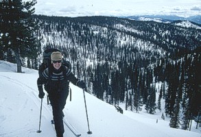
It was on our fourth day, the day after the snowmobile tracks had come to an end that we awoke to the mist. As we skied along, the movement of the mist was mesmerizing, flowing first in one direction and swinging back another, and settling over the landforms like a down comforter coming to rest on a bed. We had a welcomed break that morning. To this point in the trip, we had been largely gaining elevation, but now the trail angled downward towards a major saddle in the ridge. The conditions for downhill skiing were perfect: a light new layer of snow sitting on a firm base and a long gradual and dreamlike descent for 1,000 feet.
The descending trail, however, had lots of dips. At first I thought they were wind drifts--and Kathy countered that they were left by snowmobiles--but then, looking closely, we both realized that they were caused by the trees, mostly hemlocks in this area, that lined the trail. Since the Bitterroots are exposed to wet Pacific weather patterns, and therefore, plentiful snow, the wells that form at the base of conifers are more defined than what you might find in shallower snow climates. As the winter wears on, they become even deeper, and narrow trails passing through mature forests take on a roller coaster appearance.
We didn't care. It was all downhill, and through the mist, we could hear each other's howls and hoots as we glided over the dips and rises, and the trail angled down and down. Nearing the end of the downhill run, we watched misty fingers snake through the openings in the trees--and then as we reached the open saddle, it all came to one grand climax, with the mist arranging itself into two horizontal planes: the lower one moving one direction and the upper, the opposite. Sliding down the last hundred feet onto the saddle, it almost seemed like we had floated into another world.
At the saddle, however, the fun was over. From there we began regaining the 1,000 feet we had lost and then some. It was done in fits and stops, mostly for my benefit to deal with a little matter that involved waxing.
This wasn't the only time I had problems with wax. It was an everyday problem. All during our trip we experienced a variety of conditions. It would cool and lightly snow. Then it would warm and melt later in the day. Then it might snow on top of the warm, wet old snow. For a while I used skins, but when the trail leveled and rolled along, the skins created too much friction and were slow and inefficient.
Kathy, being the bright person she is, was using her waxless skis and she didn't have a bit of problem, going up and down with ease. Meanwhile, I was constantly pulling to the side of the trail and stopping to change wax. In order to get any kind of grip in wet snow, I used klister wax--you know the stuff that comes in a toothpaste tube, is stickier than glue and gets all over your mittens, jacket and pack. But if a little fluff fell after putting on klister, the new fresh snow would cling to the bottom in great, huge clumps. When that would happen, I'd grind to a halt, use white gas to dissolve the klister, and then re-coat the skis with a hard wax. Then, in an hour or two, it would warm again, and the hard wax, of course, would be worthless, and I'd stop again to re-apply klister. Some days I was stopping four or five times to remove or put new wax on.
All this time, Kathy humored me. Each time we stopped, she would set her pack down, and propping herself up in comfortable position, she'd lean back taking in the view as I worked away. "This," she told me at one stop after some reflection, "is a waxing fanatics' fantasy." I groaned.
That night, camped near the top, I built a fire to dry out Kathy's soaked boots and socks. The wood was predictably damp, and smoke drifted in all directions as we attempted to keep the boots from getting singed while they hung from their make-shift drying rack. After a couple hours of feeding the fire and dodging smoke--and with her boots not much drier than when we started-- we finally call it quits and crawled into our bags.
* * *
The next day, we reached our highest point on the trail, a locale known as Indian Post Office. It is so named for two large rock cairns, the individual stones of which, the story goes, were arranged in different manners by Nez Perce Indians to convey messages to one another. That may be more of a white man's tale than reality for there isn't much documentation to support that purpose--and, to us it was a moot point, not being able to see the cairns which were way, way down under the snow some place. Mostly, we had been looking forward to the Post Office for its high and airy viewpoint overlooking the surrounding mountains. Alas, it wasn't the best of days for viewing: the sky remained overcast limiting what we could see and the wind on the exposed ridge was abysmal. We paused for a quick look, and then took off down the gradual open ridge, making gentle snow plows turns back and forth until finding a protected spot just off the top and away from the wind.
We could have dropped farther down into the forest, but we decided to camp high, just in case the weather might clear the next day. And you know what? That's exactly what happened. The next morning we awoke to an incredible blue sky. After five days on the trail, we finally had great weather and a view. Quickly taking down camp and leaving our packs behind, we skied to the top of nearby Indian Point. And, there they were, the Bitterroots in all their glory.
Clark had described the Bitterroot range as "high rugged mountains in every direction." That's exactly what we were seeing now. The mountains did stretch in all directions, without any sign of relief.
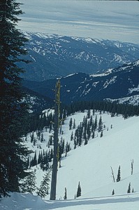 As we stood there looking over the scene of endless mountains, I understood better why the Bitterroots seemed so daunting to the explorers. For them, it was all unknown. We had our topographic maps and a trail that was obvious most of the way. We knew that if we stayed on the trail, it would eventually drop to a lower country. Lewis and Clark had been told by Old Toby that they would eventually reach a prairie where they would find more plentiful game and other food sources. But, still they couldn't see it--and seeing it meant everything. Whenever they could get a view, all they could see was more of the same: mountains with eternal snows.
Finally, on September 19, twenty miles to the west of where we were stood, Lewis wrote: "Set out this morning a little after sunrise and continued our route about the same course as yesterday for six miles. When the ridge terminated and we, to our inexpressible joy, discovered a large track or prairie country lying to the SW."
To our inexpressible joy: what beautiful words. The mountain from which Lewis first glimpsed the prairie--from which the view inspired him to write those poetic words--is called Sherman Peak. It was from the sparsely treed summit of this gentle mountain that Lewis, for once really knew that there was indeed an end to the mountains. "The appearance of this country, our only hope of subsistence, greatly revived the spirits of the party, already reduced and much weakened for want of food." They would make it!
We too could see our end. We could look to the south, down into the deep Lochsa canyon, some 4,000 vertical feet below. It would be one more night for us, our sixth on the trail and then a long descending ski out.
When the explorers came out of the mountains, they were helped by the Nez Perce Indians. The Nez Perce shared with them their food-- camas roots and salmon--and helped the party build dug-out canoes for the final stretch of their journey down the Clearwater and Columbia Rivers. When Lewis and Clark eventually reached the waters of the ocean a month later, they had much to thank the Nez Perce for. It was the Nez Perce trail that they followed over the Bitterroots. Moreover, the Nez Perce could have easily overpowered the expedition and obtained a supply of weapons far exceeding any tribe in the Northwest. They didn't, however. Instead they provided food and refuge after the anxieties of the mountain passage.
For us, our refuge would be Lochsa Lodge. We'd been talking about it for days. I think that's one of the side benefits of spending time out for a period of time. While we love being outdoors, we also love coming back. Part of the attraction of doing trips like these is the return journey from whence we come. Civilization, home, family and friends take on a new light of importance. On the trail, we both talked longingly about taking warm showers. Kathy talked of getting her boots dry for the first time in a week. I talked about a big, filling meal in front of the immense rock fire place in the lodge.
But first, one more night--and one more storm--on the trail. We camped near a formation called the Devil's Chair, a promontory of largely flawless rock, rising nearly 100 feet from its downhill side. Like most nights on our trip, it snowed, but the wind accompanying this storm was particularly strong. Even though I had built a snow wall around the tarp, wind-driven snow sifted over the wall and under the edges of the tarp.
 I woke up at regular intervals to brush the snow off our bags. At one point in the night, I felt pressure on my bag as if Kathy had rolled over against me. But it wasn't Kathy. Instead, I found a drift had partially covered Kathy's bag and was extending to cover mine. I grabbed the shovel, dug out a trench on either side of us, and then pushed the snow off the bags into the trenches. Fortunately, about that time the storm was losing its punch. Much to my relief the drifting stopped--and, in the morning, I groggily awoke to clear skies and five inches of new powder.
From our camp, it was a quick trip out: all downhill, a 3,500 feet descent, along a steadily dropping snowbound road, ending at our waiting vehicle parked along the Lochsa River. Inside, Mike Lewis had left us a little treat: two bottles of juice and candy bars.
We immediately drove to Lochsa Lodge, thanked Mike for his welcome gifts, and paid for a small wood-heated cabin for the night. We stoked the fire, strung nylon cords from the rafters and festooned the room with wet clothes and sleeping bags. The shower room was a separate building, a rustic affair with icy cold linoleum floors, but what a treat the shower was. For dinner, we were served extra large meals thanks to Mike putting in a good word for us to the chef.
Afterwards, sitting beside the big fire in the lodge and soaking in the heat, I thought about Lewis and Clark and the spirit of adventure that they embraced. The way that they responded to the challenge of their march through the Bitterroots says much about them and their party. But it also says much about modern day North Americans. In a way, we're all descendants of that spirit, people like Mike Lewis and those that love wild places, and who spend time in the outdoors: cross-country skiing, backpacking, canoeing, climbing. That's an important and uplifting part of their story. The spirit that motivated them 200 years ago is still alive and well and motivates us today.
END
A Great Read...
If you enjoyed this story, you would also enjoy Never Turn Back. It's been widely acclaimed as a captivating book. t's been widely acclaimed by reviewers and readers alike. The standard book trade reference Books in Print calls it a " masterfully written book" and "one the outdoor world's finest works." The book also appears on a number of best reading lists. Click here for more information. |
||||
And Another . . .
The book is truly a classic, one reviewer calling it the "standard by which other guidebooks are judged." Click here for more information on Winter Tales and Trails.
|
||||
More Resources...Looking for a great book on the Lewis and Clark expedition? Then you must get a copy of Undaunted Courage by Stephen Ambrose. I can't say enough good things about the book. It's a wonderful work. More Information.
|
||||
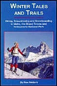
 If you are interested in stories of skiing in the old days, you'll want to pick up a copy of Winter Tales and Trails. It's full of historic information on skiing. Plus, it's a guidebook to backcountry, cross-country and snowshoeing trails in Idaho, Yellowstone and Grand Teton National Parks.